

Bhu Naksha Maharashtra (भू नकाशा) is the government’s free online land map: every plot in a village drawn with its boundary and its survey or gat number. Open Mahabhunakasha, choose Rural or Urban, then your district, taluka and village, and search your gat or survey number. The plot is highlighted, the Plot Info panel shows its area and recorded holders, and Map Report → Show Report PDF gives you a printable map. It needs no login and costs nothing, but the printout is for reference only. To see where the plot actually sits among fields and roads, the BhuMe app lays the same map over satellite imagery.
What is Bhu Naksha Maharashtra?
Bhu Naksha is Maharashtra’s cadastral map: the official drawing of every plot in a village, with its number, its shape and the plots around it. The state’s version runs on the Mahabhunakasha portal (महाभूनकाशा) of the Land Records Department (Bhumi Abhilekh). People look for it under many names: bhu naksha, maha bhu naksha, Mahabhulekh naksha, bhu naksha map, village map, gat number map or जमीन नकाशा.
It is the map half of the land record. The 7/12 utara tells you who holds a survey number and how much area; Bhu Naksha shows where that number is and what shape it has. You need both before you buy land, take a loan against it or argue about a boundary.
How to check Bhu Naksha Maharashtra online
The flow is the same on a computer and in a phone browser:
- Open the portal. Go to mahabhunakasha.mahabhumi.gov.in/27/index.html. 27 is Maharashtra’s state code. If the bare home page keeps loading, this direct address usually opens.
- Choose the category. Pick Rural for village land with survey or gat numbers, or Urban for city-surveyed areas with CTS numbers.
- Choose district, taluka and village. Rural district names appear in Marathi with a code (for example “25 पुणे”). Large villages are split into भाग 1 / भाग 2, so check both parts.
- Find your plot. Type the number in Search Plot No, or pick it from the Select Plot No list. The map zooms to the plot and outlines it.
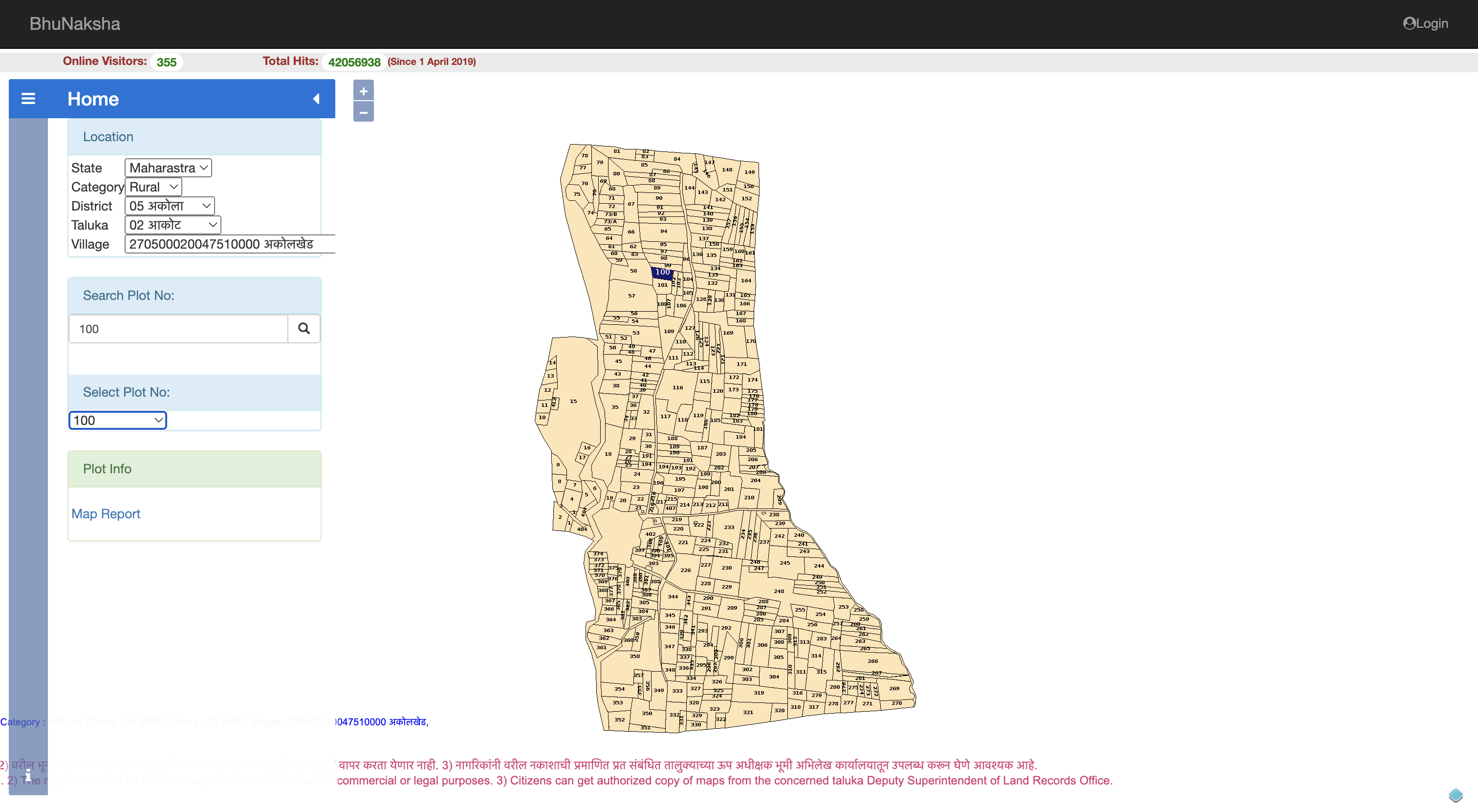
- Read the Plot Info panel. It shows each holder recorded against the number, with area and khata number (more on this below).
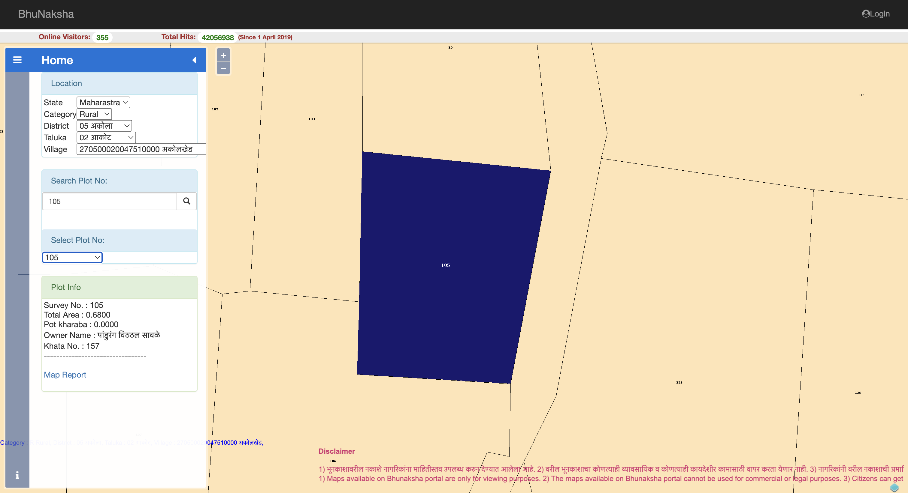
- Open Map Report to get the printable plot report.
How do I find a plot by gat number or survey number?
Search with the number exactly as it is printed on your 7/12. Maharashtra uses three kinds of plot number, and each one belongs to a different category on the portal:
| Number on your record | Where it is used | Category to pick |
|---|---|---|
| Survey number + hissa (15/2) | Villages that kept the original revenue survey | Rural |
| Gat number (गट नं) | Villages whose holdings were consolidated (एकत्रीकरण scheme) | Rural |
| CTS / city survey number | City-surveyed areas, where the record is the property card | Urban |
A hissa makes a different entry: 15 and 15/2 are separate plots in the list. If you don’t know the number at all, take it from the 7/12 or the 8A utara of the holding. When a number “doesn’t exist”, it is usually the right number in the wrong category.
How to download the Bhu Naksha Maharashtra PDF (plot report)
Click Map Report after selecting your plot. The report page gives you three choices:
- Scale: Actual Scale, Best Fit or Custom
- Report: a Single Plot, or All Plots of the same owner in that village
- Show Report PDF: opens the map in a new tab to save or print
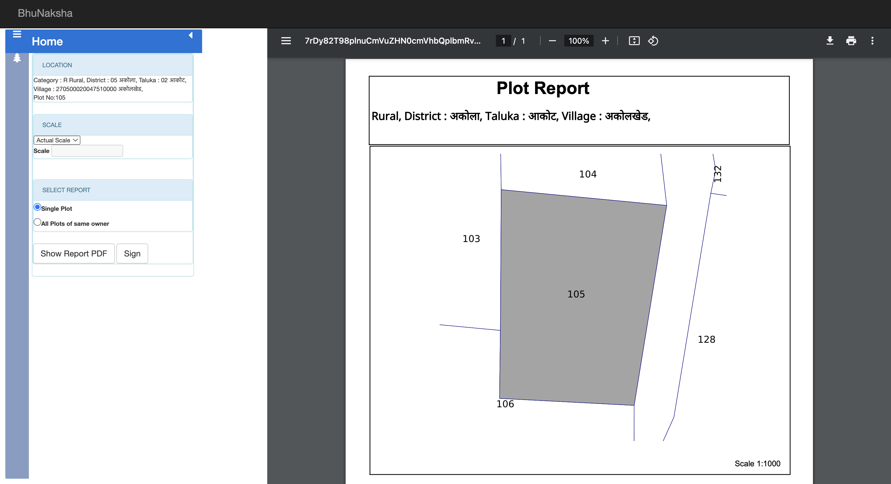
Choose Actual Scale if you plan to measure anything on paper. Best Fit stretches the drawing to fill the page, which is easier to read but no longer to scale. If the PDF doesn’t open, allow pop-ups for the site; the report opens in a new tab. For the full printing walkthrough in Marathi terms, see our जमीन नकाशा guide.
What does the Plot Info panel show?
For a selected plot, the panel lists one block per khata (account) recorded against the number:
| Field | What it tells you |
|---|---|
| Survey No. | The survey or gat number, with hissa if the plot is subdivided |
| Total Area | The holder’s recorded area in hectares (0.40 ha ≈ 1 acre ≈ 40 guntha) |
| Pot kharaba | The uncultivable part included in the plot |
| Owner Name | The holder’s name in Marathi, as on the land record |
| Khata No. | The account number that links the holder to the 8A |
A single gat often has many holders, and the outline on the map covers all of them together. The panel is unsigned reference data; anything you act on should be checked against the digitally signed 7/12. To convert the hectare figures, use the land area converter.
Bhu Naksha vs 7/12 vs property card: what is the difference?
Each document answers a different question about the same land:
| Document | Answers | Where to get it |
|---|---|---|
| Bhu Naksha | Where is the plot and what shape is it? | mahabhunakasha.mahabhumi.gov.in (free) |
| 7/12 utara | Who holds rural land, how much, any charges | Mahabhulekh / digitally signed 7/12 |
| 8A utara | All the plots one holder has in a village | Mahabhulekh / digitally signed 8A |
| Property card | Who holds a city-surveyed (CTS) plot | Mahabhulekh / digitally signed copy |
| Index 2 | Which registered deeds touched the property | IGR Maharashtra free search |
The map never proves ownership, and the 7/12 never shows the boundary. A proper land check reads them together.
Is a Bhu Naksha printout legally valid?
No. The online map and plot report are reference copies. For legal work there are two certified maps:
| Map | Where it comes from | Legal weight |
|---|---|---|
| Bhu Naksha plot report | mahabhunakasha.mahabhumi.gov.in, free, instant | Reference only |
| Certified survey map copy | Taluka Land Records (Bhumi Abhilekh) office, copy fee | Certified |
| मोजणी नकाशा (क-प्रत) | Issued after an official e-Mojani measurement | Certified |
| Satellite overlay (BhuMe app) | Cadastral map drawn over satellite imagery | Reference only |
Under the Revenue Department’s fee order of 22 June 2026, a regular measurement costs ₹2,000 for up to 2 hectares of rural land and takes about 90 days; fast-track costs ₹8,000 (rural) and takes about 30 days. Use the free map to screen; pay for a measurement only when a sale of part of a plot, a fencing dispute or a court case depends on the exact line.
Is there a Bhu Naksha Maharashtra app?
There is no official government Bhu Naksha app for Maharashtra. Apps called “Bhu Naksha” on the Play Store are made by private developers, and some only open the government website inside an app. The portal itself works in a mobile browser at the same address.
The BhuMe app is a private app too, and it does something the portal cannot: it draws Maharashtra’s cadastral maps on real satellite imagery, so you can find a plot by gat number or owner name, see which field it is, and open its 7/12 on the same screen.
Bhu Naksha not working? Common problems and fixes
- The site keeps loading. Open the direct state page (mahabhunakasha.mahabhumi.gov.in/27/index.html) in a normal browser tab with cookies allowed, and try outside weekday office hours, when the server is slowest.
- “No data found” or the village is missing. Switch between Rural and Urban, check the भाग 1 / भाग 2 entries, and look for spelling variants of the village name. If it is really absent, the map hasn’t been digitised yet; the paper village map is available at the taluka Land Records office, and you can report the gap to the directorate at dlrmah.mah@nic.in.
- The map stays blank. Wait a few seconds, zoom once to force the tiles to reload, or reselect the village.
- My plot number isn’t in the list. Match the hissa format on your 7/12. A newly created number appears after its mutation is certified, so check the ferfar status first.
- The PDF doesn’t open. Allow pop-ups for the site.
Older scanned survey records and maps are also being put online on the Aaple Abhilekh archive.
What changed for Maharashtra land maps in 2026?
On 9 September 2026 the state launched MahaBhumi Stack, a single portal that brings together more than ten land-record services, including 1.5 million land maps, 36 million scanned legacy documents and 400 million mutation records (UNI report). Mahabhunakasha continues to serve the village maps at the address above. Separately, measurement maps from e-Mojani 2.0 now come digitally signed, with coordinates for each boundary point, and new measurement fees apply from 22 June 2026.
Which districts have Bhu Naksha online?
All 36 districts are on the portal. The Urban list shows all 36; the Rural list shows 34, because Mumbai City and Mumbai Suburban have no rural villages. Inside a district, a few villages may still be missing where digitisation isn’t finished. Aurangabad and Osmanabad now appear as Chhatrapati Sambhajinagar and Dharashiv in most state records.
For a whole-district view of the 7/12 side, see our district pages for Pune, Nashik and Nagpur, or start from the Maharashtra land records hub.
See your Bhu Naksha on a satellite map
The portal draws your plot on a white sheet; it can’t tell you which field by the road is yours. BhuMe overlays Maharashtra’s cadastral maps on satellite imagery with owner names, so “gat 214” becomes “the field next to the well”. Search by gat number or owner name (Marathi is handled for you), check the boundary against what you were shown, and share the map and records on WhatsApp. Open BhuMe.